


The clock in historical context, part 2
the problem with longitude

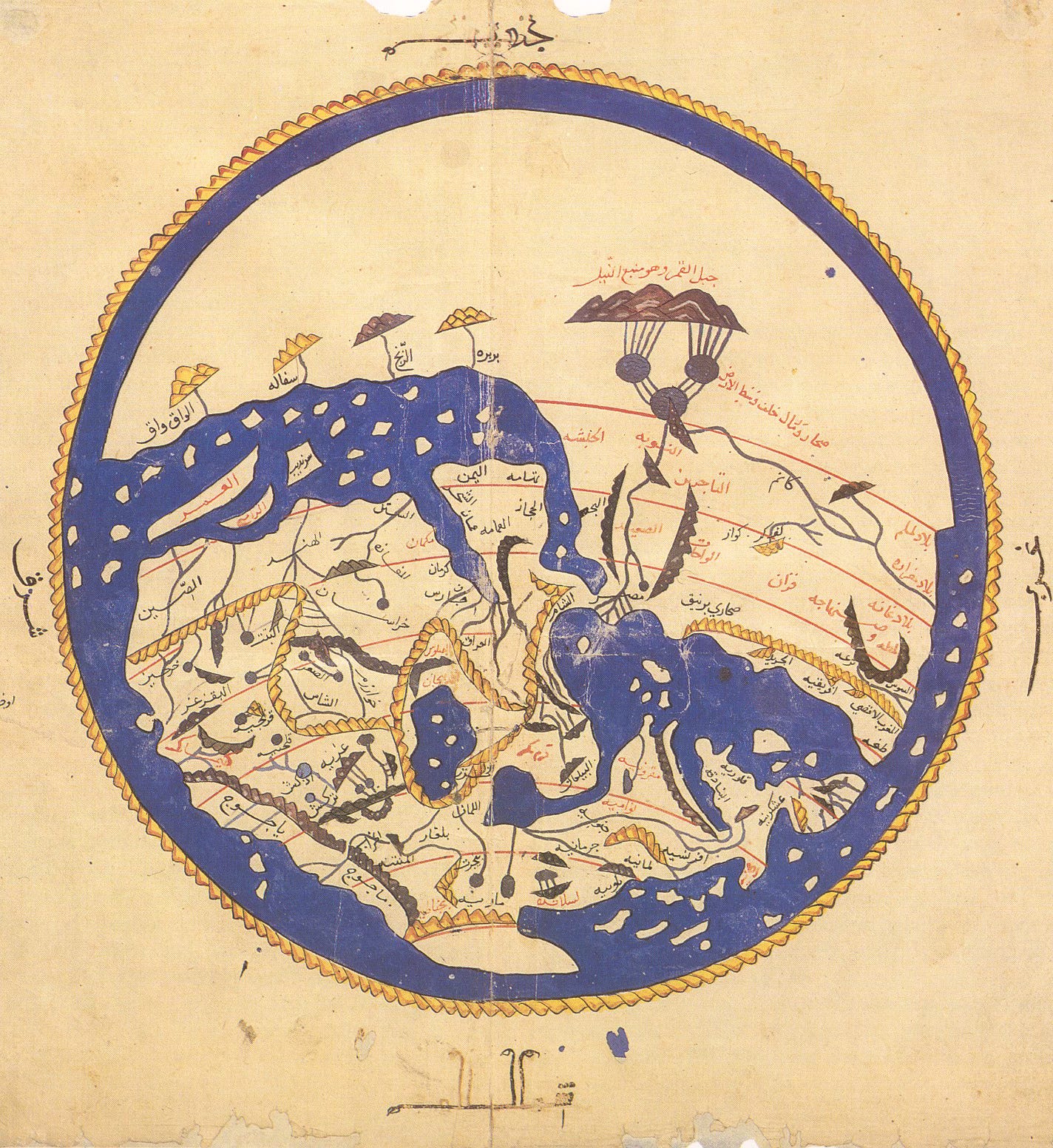
So, the Prague clock is designed for 50 degrees north latitude. (If you haven’t read the first post in this series, check it out first.) What role, then, is played by the longitude of Prague, approximately fourteen and a half degrees east of the Prime Meridian? As the Earth spins, the Sun appears to rise in the East, pass through a great arc in the sky, and set in the West. The midpoint between rising and setting is called the midheaven, or medium coeli, and the moment the Sun arrives there is “solar noon.” This is the true astronomical midday for a given location on Earth. (For any place north of the tropics, such as Prague, the Sun is directly south of the viewer at the moment of solar noon. This is why, as described in the first part of this series, the post-WWII clock face had the map of the world oriented with south at the top, the direction the hour hand points at 12:00 noon. Some map traditions in history, such as the maps of the classical Islamic world, were oriented this way for the same reason.
Because lines of longitude run north-south, parallel to the axis of the Earth and perpendicular to the direction of rotation, every point along a single longitude experiences solar noon at the same moment. As locations become further and further apart in longitude, their solar noons diverge from one another, even if their latitude is the same. As there are 360 degrees in any circle of latitude and twenty-four hours in the day, it takes one hour for the line of solar noon to travel fifteen degrees of longitude westward across the surface of the Earth, or four minutes to travel one degree. The correspondence of one degree of longitude to four minutes of time will recur in other places and is a worthwhile constant to remember.
For example, Prague, Czechia; Östersund, Sweden; Naples, Italy; N’Djaena, Chad; and Kinshasa, Congo are all within about one degree of longitude from one another, and so their true solar noons fall within a space of about four minutes. By contrast, Amiens is on the same latitude as Prague, but it sits more than twelve degrees to the west. From the moment of solar noon in Prague, it takes about forty-nine minutes for the Earth to rotate before solar noon occurs in Amiens.
And yet, clocks in Prague show the same time as clocks in Amiens. This is simply because people in most places on Earth do not set their clocks to true local astronomical time, but to a negotiated time standardized with people in other nearby places. These negotiated standards are what we call time zones. Before the advent of high-speed, long-distance train travel and telegraph communication, there was no need to coordinate time in this way, and so each locale observed and measured its own astronomical time.
Efforts to standardize time across long distances began with expanded European ocean navigation in the sixteenth century. While latitude can be determined relatively simply through celestial observation, the same is not true for longitude, exactly because every point on a given latitude is interchangeable relative to the Earth’s axis. To determine longitude—and therefore avoid running one’s ship aground in the fog—requires knowing the precise time at a known point on Earth. By comparing the local observed astronomical time (by measuring the height of the Sun or of some prominent star) to that of the known point, a navigator can calculate how many degrees of longitude separate them from that point, using the constant ration of four minutes of time per degree.
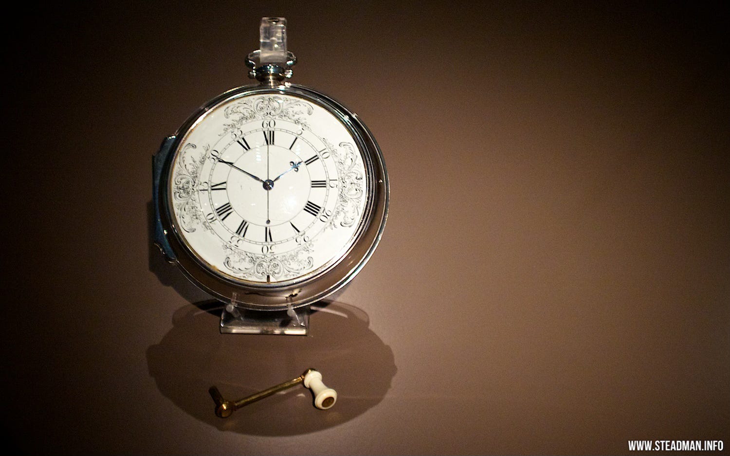
The founding of the Royal Observatory in Greenwich in 1675 created a fixed time standard for British mariners, who began carrying clocks set to Greenwich Mean Time, or GMT, on ocean voyages. By measuring the local astronomical time and comparing it to GMT, they could determine how far east or west of Greenwich they were. This in turn spurred a revolution in the technology of making accurate, portable clocks that could withstand the rigor of ocean travel and didn’t rely on pendulums or sand or any other physical mechanism that would be affected by a ship’s motion. By 1761, John Harrison had created a five-inch diameter watch accurate enough to tell a ship’s location within one nautical mile after a trans-Atlantic journey.
As land transportation and communication became faster, it became increasingly necessary to coordinate time between locations with different solar noons. Starting in the 1840s, British railways began to adopt GMT as a standard for scheduling trains, even as individual towns and cities kept their specific astronomical time for local affairs. In 1858, Quirico Filipanti proposed a series of twenty-four “longitudinal days” to organize global time. A decade later, New Zealand became the first territory to adopt a single time zone for all purposes. By the end of the century, most places on Earth had done the same, though many of these were pinned to the astronomical time of a major local city, and not to Greenwich: the first time zones coordinated time on a regional or national scale, but were only gradually integrated into a global standard system. The most recent adjustment to the global time zone map was made in 1986, when Nepal broke from Indian Standard Time and adopted a standard five hours and forty-five minutes ahead of GMT.
If you’ve made it this far, here is the party trivia payout for you. The next time someone comments on how strange it is that Nepal has a time zone offset by fifteen minutes from “normal,” point out that Kathmandu sits at 85 degrees east longitude, and so solar noon occurs there five hours and forty minutes before it occurs in Greenwich. (85 degrees times 4 minutes per degree equals 340 minutes.) The fact that Nepal chose five hours and forty-five minutes for its time zone actually represents an accommodation between local and international time standards.
All this happened much later, and much of it happened much further out to sea, than the creation of the Prague astronomical clock. In the early fifteenth century, Bohemian clockmakers only needed to measure local time. So, they built an astronomical clock suitable for fifty degrees north latitude, and they set it to align with the solar noon of Prague. In the 1890s, as time zones were being consolidated worldwide, Prague and Budapest—and after them Vienna—adopted a single time standard, which they defined as one hour ahead of GMT. This was the beginning of what we now call Central European Time, or CET.
Remember that one hour represents the time it takes for the Sun to move through fifteen degrees of longitude, and so CET is by definition the local astronomical time for the line of 15 degrees east longitude. As we have seen, Prague sits just fourteen- and one-half degrees east from Greenwich. As a result, Prague local astronomical time is almost exactly one hour (57 minutes, 41 seconds, to be precise) ahead of GMT, and only just over two minutes slow of CET. As the Austro-Hungarian Empire adopted CET, the Prague clock happened to match it quite closely. An astronomical clock designed for Vienna would be almost five- and one-half minutes fast compared to CET, and in Budapest that deviation exceeds sixteen- and one-half minutes.
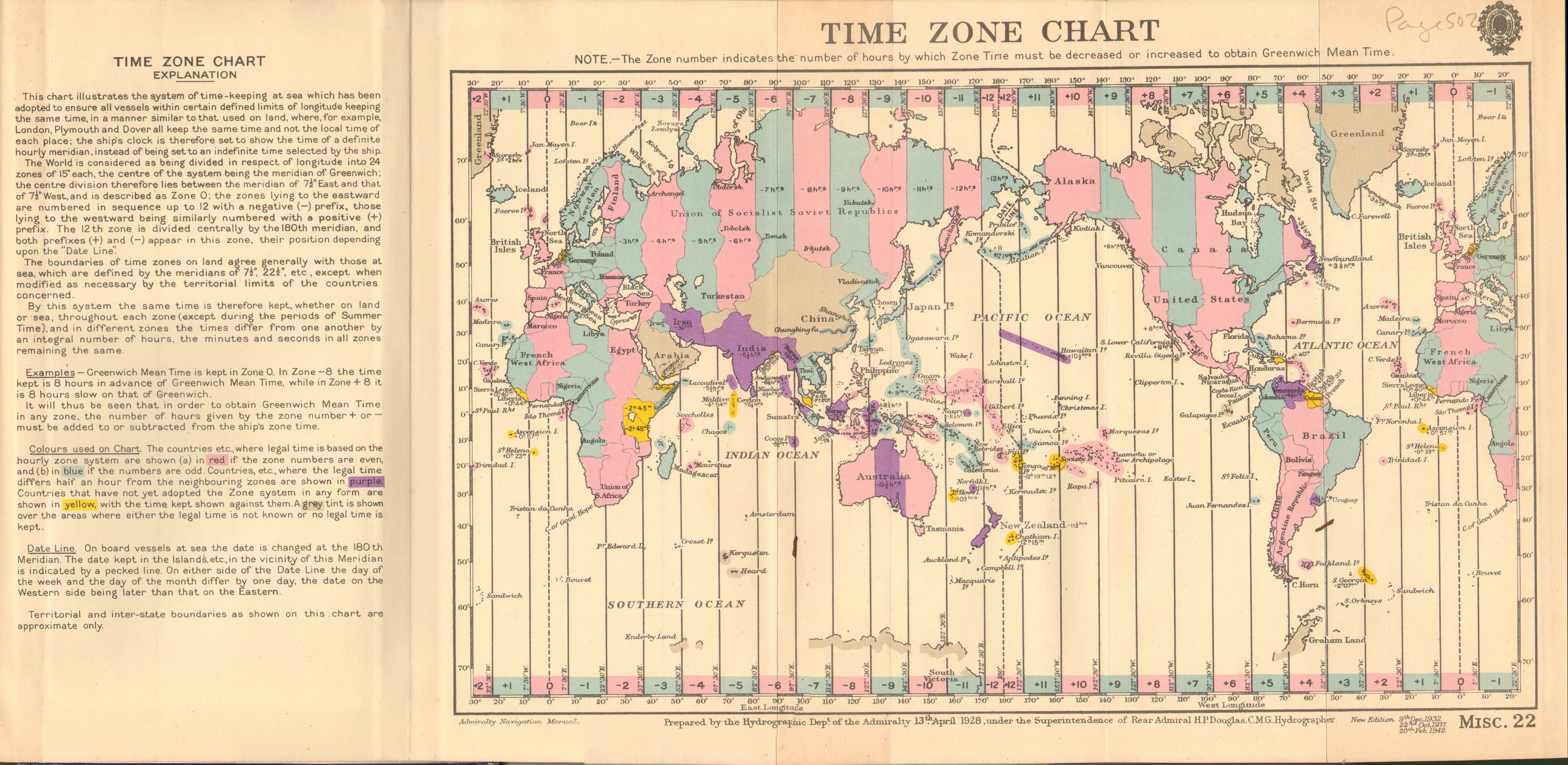
The image above shows the situation of time zones in 1928. Longitude is shown in fifteen-degree increments, indicating the theoretical ideal time zones. Areas in pink and blue had adopted time zones a full hour before or after GMT; areas in purple were on a half-hour time zone. Areas in yellow observed a local time standard, and grey represents “areas where either the legal time is not known or no legal time is kept.” Notice that France and Spain are on the same time zone as Britain.
In the decades after the core Austro-Hungarian lands embraced Central European Time, neighboring regions of Europe adopted CET until, in 1940, Nazi Germany imposed it on all occupied territories and Francoist Spain followed suit. As a result, Madrid and Amsterdam found themselves suddenly using a time standard appropriate for Prague: a fascist reunification of Habsburg lands. With the end of WWII and the rise of the European Union, a single time standard across Europe retained its appeal, and most of continental Europe remains on CET to this day.
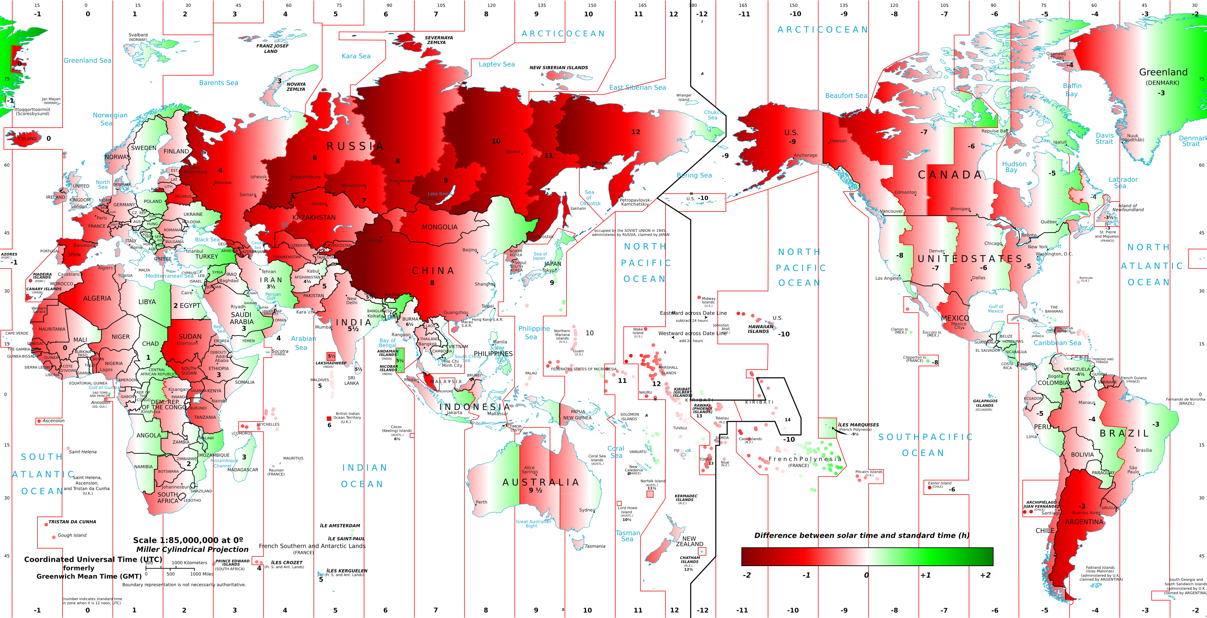
The fact that most of the territory using Central European Time sits far to the west of fifteen degrees east longitude is entirely in keeping with global practices. Using a time standard based to the east of one’s location makes for lighter and longer evenings, more opportunity to spend time outside after work, so most time zones stretch further west from their theoretical center than they do east. This is the same reason that many places observe Daylight Savings (Summer Time in Europe), which in effect pushes a location’s time standard fifteen degrees further east. In summer, Madrid uses a time standard astronomically appropriate for Kyiv.
As we will see in other posts, the Prague astronomical clock is, in effect, a model of the universe from the perspective of the surface of the Earth. While it is universal in scope, it is designed specifically for a city as far north as Prague, and only in Prague does it also happen to align with modern time standards. When the makers of the clock—and we will get to them in time—designed a device to tell local astronomical time with remarkable precision, they could have never foreseen that, after centuries of global empire, oceanic exploration, mechanized transportation, and instantaneous communication, it would do a fair job telling local time not only for the citizens of Prague, but for those of Budapest, Amiens, and Madrid. If it wasn’t for the convergence of luck and history that had the British build their royal observatory almost exactly one twenty-fourth of a globe west of Prague, the astronomical clock today would have to either misrepresent local astronomical time or the negotiated standard European time. Tourists today can overlook the two minute and nineteen-second difference and marvel at a clock that tells the time and shows the universe. Part of me wonders if this is the secret behind the clock’s survival.